产品描述
Product Description
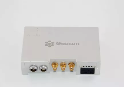
GPS BDS GLONASS GNSS INS System For Positioning And Altitude
AGS 300 GNSS INS System adds a high-precision inertial navigation (IMU) module, no matter how the fuselage tilts during the aviation flight, it can accurately provide position, velocity and 3D attitude information.
After the data processing of professional software, AGS 300 provides threedimensional position accuracy of 0.05 m, velocity of 0.02 m/s, heading of 0.080 degree, and pitch/roll of 0.030 degree, data sampling rate ups to 200Hz. With AGS 300, UAV Aerial remote sensing can completely be free from ground control point, it is especially applied to the UAV surveying in strip area, irregular shape area, large watershed area and high latitude area; and is also widely used in UAV laser scanning and other direct geo-reference aerial remote sensing fields. For the users who required high-precision and real-time in precision agriculture, electricity and other areas, AGS 300 also offers GNSS real-time differential positioning (RTK) function.
- 无人机
- 无人及配件
- 雷达
- 硬件
- 导航
产能:
未通知
运输时间表:
根据订单的规模
Incoterms:
未通知包装明细:
未通知
更多关于
Shenzhen Nuobashi Trading Co.,Ltd
10-50
员工
未通知
100%
% 出口销售额
Year
成立年份
业务类型
- Industry / Manufacturer
- Distributor / Wholesaler
关键词
- 半导体
- 汽车诊断仪
- 无人机
- 示波器
- 电子元器件
联系方式和位置
-
Weili ********
-
+86 1********
-
深圳 / | 中国


